If walls could speak, they could tell quite a tale. But the land of the College Campus, predating all our buildings, has quite a history, too.
The story of the land that encompasses the College or Charleston campus reflects the history of the city.
The peninsula of Charleston was home to Native Americans long before the first permanent European settlers arrived in 1670. As soon as they entered the harbor, the first settlers saw a large oyster midden, the mounds of discarded oyster shells left by the indigenous people. (They named that area White Point, the site for White Point Garden today.) The tribes in the area included the Wando and the Etiwan. Relations between natives and newcomers started out equitably, but the sad tragedy of native displacement by the Europeans (through enslavement, conflict and disease) that is part of American history also played out here.
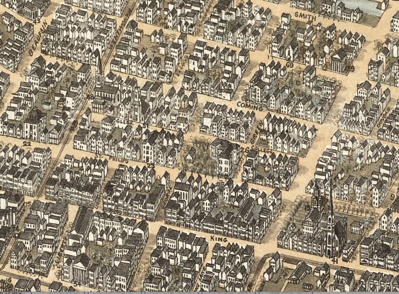
No one owned the lands, until they were claimed by England’s King Charles II, who granted them to the Lords Proprietors, who, in turn, granted them to others. What is now our campus was beyond the limits of Charles Towne, which was moved from its original location at Albermarle Point, west of the Ashley River, to the peninsula in 1680. Our land, granted first to Henry Hughes in the 1670s, passed to John Coming. In 1698, a part of that parcel, containing the core of the campus, was conveyed by Coming’s widow, Affra Harleston Coming, to the Pinckney family. (The names of Coming St., which runs through campus, and Harleston Village, just west of it, reflect this early history.) In 1724, a Pinckney heir sold some of this land to the Commissioners of the Free School, making public education the land’s now fulfilled destiny. The large tract of land bounded to the north on a marsh (now Calhoun St.between St. Philip and Coming streets, an area that still floods occasionally) and southerly (south of present-day George St.) on a tract donated by Affra Harleston Coming to St. Philip’s Church. (This gave rise to other street names in the neighborhood – St. Philip and Glebe – the latter word meaning property of a church.) Some of the first structures on the land in the Colonial era were wooden barracks, soon replaced by two brick barracks. The barracks were used in the American Revolution by the Second SC Regiment under William Moultrie. Plats indicate that those buildings were in the approximate area of what is now Cistern Yard.
The College’s first president Bishop Robert Smith, who lived nearby, was not just a clergyman, but a plantation owner whose wealth came from enslaved people who worked his land. (Almost all early endowments came from similar sources: Benjamin Smith, the first contributor to the College, no relation to Robert Smith, was a wealthy slave and plantation owner, as well, and Miles Brewton, another donor, was a slave trader.) President Smith, who would own more than 200 human beings at his death in 1801, was in the position to advance the struggling College funds to repair the barracks classrooms; records also reveal that people he enslaved worked on related projects, for which he billed the institution. To pay off those debts after his death, the College trustees, mostly wealthy slave owners themselves, cut Green Street (now Green Way, converted to a pedestrian mall in the 1970s) through its lands, attempting to rent lots along it. The College’s land was now quartered into four approximately equal squares or blocks, the extreme outer limits being Boundary (now Calhoun), St. Philip, George and Coming streets, with College Street running north/south through the parcel, and Green Street running east/west through it. In 1817, the College was forced to sell most of its land to satisfy the debt, restricting its precincts to the southeast square of land bounded by George, College, Green and St. Philip streets.
On these lands, fringing the compact campus, rose houses, large and small, of men and women white and black, free and enslaved, many of whom could not legally attend the school whose student body consisted mostly of the white slave-owning elite. (There were religious, educational civic buildings and graveyards in the neighborhood, too.) As the College grew and eventually became state supported in the 20th century, it began to acquire more of the surrounding property. Many buildings were torn down, some were saved, and others relocated. After all these changes, the College of Charleston now includes the approximate parcel it possessed at its founding, and more: the campus now extends north of Calhoun Street, east of St. Philip Street, across Coming Street and as far south as Wentworth Street. There are other non-contiguous College lands on the peninsula and others across both the Ashley and Cooper Rivers.
Within the over 30 acres of the downtown campus are innumerable stories to discover.
Audio
Images


